Thursday, March 29, 2007
St John's Chuckatuck
St John's, Chuckatuck N36.85699 W76.56106 1756
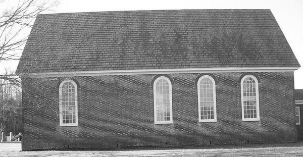
This medium-sized church, 60' x 30', has much to recommend itself despite extensive repairs to its brickwork, windows, and interior. It stands in the middle of a copse of beautiful shade trees by the side of a small pond running to Cedar creek.
It is apparently the third church on the site, and is the only church not oriented but has the chancel skewed to the northwest instead of true west. I wonder if the builders oriented the church to the site and only roughly east-west? Another unique feature is that it is laid in Flemish bond below as well as above the water table. Old pictures I found in a book by George Mason in the nearby TCC library show the church with a collapsed roof and report extensive restoration to the brickwork that is evident even to a non-architect's eye like mine. The effect of the windows is greatly diminished by the nineteenth century panes with diamond panes and translucent lights.
Perhaps I've been visiting too many remote churches with superb brickwork or recent, seamless restorations like St John's in King William County. I seem to recall it in a better light when I used it as a stop on bicycle routes home on summer days, so the church has probably remained the same and my eye has been spoiled.
As I mentioned, the brick facades show extensive repairs with some of the windows showing changes in shape and size. The windows on the chancel end are bricked up in an unattractive, contrasting pale brick, and the lunette window over the entry door is cemented over. There is a large brick patch on the south-east center window (this is apparently the original vestry door?) and ungainly metal straps on the sides. Remember that this is nitpicking; the overall impression, especially from the south of the entry door is truly charming and pastoral. The view from the road through the trees is suitable for a moody watercolor.
Labels:
Chuckatuck,
colonial church,
St John's,
Suffolk,
Virginia
Sunday, March 25, 2007
Glebe Church
Glebe Church (Bennett's Creek Church) N36.82454 W76.49660 1737-38
Glebe Church is still an active Anglican denomination in a much changed church of which only the walls themselves remain with a greatly altered set of windows, doors, and particularly the cornice that is a jarring wooden structure on base of irregular brick repairs. The church was abandoned after the Revolution until 1856 and went through a series of changes that leave only the walls -- a portion of them at best -- as colonial. It apparently was built as a small, 49' x 25', rectangular structure and in 1759 an L-shaped addition to the north (where the new addition stands) of 24' x 23' was added. Interesting features such as galleries on both the north and west sides were present as well as a hanging pew in the southeast with an outside covered entrance. There may have been another private gallery added in 1777. Sadly all of this is gone, and the church shows, even superficially, much variation in its brickwork. The north addition was taken down in the alteration of 1856 and the surplus bricks used to repair the original-sized rectangular shape. The windows show a lot of variation, and the present windows are clearly not colonial.
Labels:
colonial church,
Driver,
Glebe chruch,
L-shaped,
Virginia
Saturday, March 24, 2007
Lyric Poems
In addition to this site documenting via photographs each church I can find, I'm currently writing a series of lyric poems to be published in a chapbook. I plan to juxtapose each poem with a series of images of each church. If you want me to post some samples here let me know via email.
2nd Southwark Parish
2nd Southwark Parish Site N37.18560 W76.85623
I went by this site for years, not knowing it was there, until a fellow Scout Master from the nearby Pipsico Camp showed it to me while I was working as a councilor for a bicycling and colonial history program there.
It consists of a set of fences to the north of Route 618, a concrete monument, and the outlines of the presumably wooden church there.
In summer, even knowing where it is. it is easy to drive right past it. If you are looking for it, I recommend a GPS
Southwark Parish
Southwark Parish Church 1754 N37.10862 W76.73557
This church was the most melancholy ruin in the state of Virginia with the walls of the church shaded even in the hottest summer by a huge oak to the south-west of the remains. Alas, in 2005 a hurricane blew the oak over and crushed the largely intact brickwork. The local historical society is now rebuilding the walls in correct bond using the droves of original bricks from the walls. The walls are irregularly Flemish or English bond, reflecting the mix of bonds on the original. I ran into a local man who name I promptly forgot and had a good old talk about the church and showed him the Rawlings book I had the foresight to bring with me. All together a pleasant late Saturday afternoon. I hope I run into more local residents as I pursue my project.
There is some confusion in parishes: Lawne's Creek, Chippokes, and Southwark Parish seem to have a rather mixed history from James City County in 1652. Lawne's Creek Parish was formed in 1640? and was represented by a first church on Hog Island near the Surry Nuclear Plant. The exact site is forever lost. According to local historians, the 2nd Lawne's Creek Church is a scant ruin on Route 618 north of Surry, Virginia. I have seen this church referred to as the 3rd Lawne's Creek Church, but Rawlings asserts is was constructed as Southwark Parish and never served any other parish. Oh, well.
The original walls measures 74' x 43', a huge building and were 2 1/2 brick lengths thick. The walls are exposed and are being rebuilt as the original with Flemish bond on the outside and English bond on the inside. A few sections of brick in the northeast corner seem to have old plaster on them with shells embedded in what looks like a mud base. I have seen shells from either the Miocene deposits on the James or, on the Eastern shore, used as driveway gravel or plaster. It this the case here? The building was abandoned from the Disestablishment until 1847, with local congregations squabbling over the building until the Civil War. It was reputedly burned down by local Blacks who wanted to keep using the surrounding cemetery for burials. There is no proof for this assertion. However, the church site is surrounded by a lovely cemetery with, as I have seen, local burials still going in.
There are also numerous cedar and other flowering trees surrounding the site that render it quite poetic. I shall return and take more pictures in late spring. Across Route 10 is Bacon's Castle built in 1665; another site well worth more than one visit.
Added to this post is a picture I found of the interior of the church in the 1980s showing it before the damage of the 2005 storm.
Labels:
Bacon's Castle,
colonial church,
ruin,
southwark parish,
Virginia
Friday, March 23, 2007
St John's King William
St John's, King William County1734 N37.61616 W76.92078
The next church cousin Tom and I visited on March 17 is St John's, King William County. It is a rare, T-shaped church with the chancel (altar) on the east and a projecting wing to the north. The north and west doorways are stunning. The north has a triangular pediment with brick column pilasters while the west has a semicircular pediment with identical pilasters. They seem identical in style to those of Stratton Major and St Stephen's we stopped at earlier in the day. According to my reading, the T-shaped and cruciform churches were not designed as a architectural feature symbolizing crosses but rather as a means to enlarge the church economically as well as to provide adequate volume for the parishioners as a rectangular church has a audible limit of 80 feet maximum. The north wing was most likely built circa 1755. The walls are cited as being in poor repair in a 1963 source (Rawlings, James S. Virginia's Colonial Churches: An Artchitectural Guide. Richmond: Garrett and Massie, 1963 -- the canonical reference source) but now seem in good repair. The windows are correct 18th century form with compass (semicircular) tops and, like the doorways and corners, have rubbed brick, made by selecting light colored bricks and literally rubbing them to give them a different pattern. These subtle touches make the buildings all the more interesting to look at. There is a modern rest room building and a kiosk with the church's history well documented that is part of a modern restoration that is itself stunning. The inside is completely restored to the 1755 condition with the correct display of the Lord's Prayer, The Ten Commandments, and the Apostles' Creed in large tablets above the communion table. I wish I had space for all that this church offers. It is available for weddings, etc., at a very reasonable rate. Quixotically, my camera ran out of battery power just as we arrived, to only two pictures are available. I must make another trip and soon. http://www.stjohnswp.org/oldstjohns/
Labels:
colonial church,
King William County,
St John's,
t-shaped,
Virginia
Tuesday, March 20, 2007
Yeocomico Church
Yecomico Church N38.06231 W76.59685
This church is an oddity. Built in 1706, it shows a transition from Gothic churches like St. Peter's (below) and St Luke's in Smithfield (Newport Parish). The two earlier churches (1701 and 1680s) have clear Gothic features like buttresses, Flemish or crow-step gables, and casement windows with small diamond panes. (St Luke's original windows were apparently Gothic Y-tracery ones with clear glass panes -- not the stained glass presently in place.)
Yeocomico is a small church, 51' x 26'-27' (different widths at west and east ends). It may have been built as a rectangular church (like St John's, King William County) and later changed to its present T-shape. It has a unique porch on the south with the only wicket door from colonial times (It is reputed to weigh over 1,000 pounds.). There are irregular variations in the brick bond throughout the walls made of bricks, according to the nearby monument, fired in a kiln on the site. The windows are covered by heavy green, wooden, rectangular, rustic shutters (We could not get in the church as no one was on site to open the church for us.) . There are three doors: two on the south and one on the north. The two south doors are marked by fantastic pilasters while the rest of the church has several brick plaques with the initials of the builders, a thistle, and Masonic (?) symbols. It is a small church that just oozes charm: all the more so because it is completely surrounded by a restored churchyard wall containing stately trees. I will visit again and give a more complete report as this site deserves it.
Labels:
colonial church,
t-shaped,
Virginia,
Westmoreland county,
yecomico
St Stephen's
Lower Church, St Stephen's (Mattaponi), King and Queen County N37.71864 W76.88687
After visiting Stratton Major Church, we found St Stephen's a few miles up the road. It, like the former church, is on a pleasantly wooded hill with a cemetery of later origin surrounding it. The church is cruciform with splendid Flemish bond brickwork marked by glazed headers. The doorways are striking, with idendical pilasters with a triangular pediment above the vestry door and a semicircular one above the west door. The bricks here seem to be by the same craftsman as Stratton Major (as well as St John's, King William County). I wonder if there was some journeyman who worked on all three churches? The shape is a Latin cross and has dimensions of 84 1/2' x 64' for the main branches east-west and north-south. It is a huge church that could seat 500-600 parishioners if Stratton Major could seat 572 (according to Dell Upton). The construction date is most likely circa 1730-1734. Another building with classical presence-- well worth more than one visit.
Monday, March 19, 2007
Blogging
I got turned on to blogging by my friend, Peter Stinson, on whose blog can be found some of my poetry, even some about the churches I visit. Read his blog for intelligent, flexible discussion of contemporary issues. http://tidewatermuse.blogspot.com/
Stratton Major
Upper Church, Stratton Major, King and Queen County N37.60285 W76.77049
This church, built between 1724-1729, has splendid brickwork in Flemish bond above the water table with glazed headers. The south doorway, in particular, with its square arches and triangular pediment is a wonder to ponder despite the jarring presence of modern storm doors. It is a rectangular church with dimensions of 64' x 33' 9' with 2' thick walls. It sits on the top of a small rise to the south of Route 14 which enhances its presence on a sunlight day. Reportedly there was an earlier church on the site whose presence was revealed by bulldozing possibly for the new west addition? Elaborate details of brickwork and the classical proportions of the building make it achieve the serenity few modern structures possess. I could almost feel the stares of 17th century parishioners as I walked around the building. Sadly, the west face is obscured by a new addition that crudely covers the magnificent pilasters and curved arch of the western entrance door. After the Revolution, the church was deserted and used intermittently by local congregations of Baptists and Methodists. It is now an active Methodist church with modern outbuildings and play apparatus. Modern maps refer to it as Old Church.
Sunday, March 18, 2007
St Peter's
Late February 2007
Visited St Peter's Church north of West Point, Virginia N37.54068 W77.05646
St Peter's is a rectangular church with a bell tower: church built in 1706; bell tower in 1740. It is only one of three extant churches with a bell tower. The structure is 64' x 28' for the main church, and is an late example of Virginia Gothic architecture with buttresses and Flemish gables. The tower has a key for St Peter at its zenith and huge quoins at the four corners. The strange protrusions on the south and north side of the tower are drains for the original two-sided tower roof. The windows are casements with diamond panes of clear glass. Note the Gothic-shaped read window, with clear glass, and the brick arch above each window. The surrounding grave yard is of later origin. It is a very peaceful place with groves of fragrant trees surrounding the church and graveyard.
Labels:
bell tower,
colonial church,
New Kent county,
St Peter's,
steeple,
Virginia,
West Point
Merchant's Hope
February 2007 Merchant's Hope, Hopewell, VA: N37.26563 W77.20213
Visited arguably the most pleasing church in Virginia, Merchant's Hope (Martin's Brandon Parish) circa 1725. On a pleasantly wooded site with aesthetically pleasing lines, this church represents the early eighteenth century ideal balance between form and function. Note the compass windows, the matching doors, and the graceful kicked eaves. The church is oriented, altar end toward the east entrance door toward the west, by law. The vestry door on the north wall is a study in simple elegance. The church itself is 60' x 25' in dimensions with 22 1/2 inch solid brick walls. The water table, lower rows of bricks on the foundation, are in English bond while the walls are in Flemish bond. The headers, or short bricks, in the walls are glazed blue-black. The inside is said to have been destroyed by Federal soldiers and was restored after the Civil War. Well worth a visit or two.
Virginia's Colonial Churches
March 18 2007
I've recently revived an interest in colonial history in southern Virginia and have begun studying and visiting true colonial churches in the greater Tidewater area. I thought there might be some interest in this topic.
I will visit each of the forty eight authentic colonial churches in Virginia and document them with GPS readings as well as verifying the condition of the buildings with credible printed sources. Email me if you want more information or have information about the churches not in the cited writings.
Subscribe to:
Posts (Atom)